- home
-
news
- arXiv
- physics
- linux
- nature
- world
- BBC
- Al Jazeera
- earth
- universe
- wiki
- gemini
- Capital Public Radio (2020) California Wildfire History Map. Accessed May 29, 2026.
- InciWeb (2026, May 28) Santa Rosa Island Fire. Accessed May 29, 2026.
- NASA Earth Observatory (2026, May 20) Fire Chars Santa Rosa Island. Accessed May 29, 2026.
- National Park Service, Channel Islands. Accessed May 29, 2026.
- Santa Barbara Independent (2026, May 21) What We’re Losing in the Santa Rosa Island Fire. Accessed May 29, 2026.
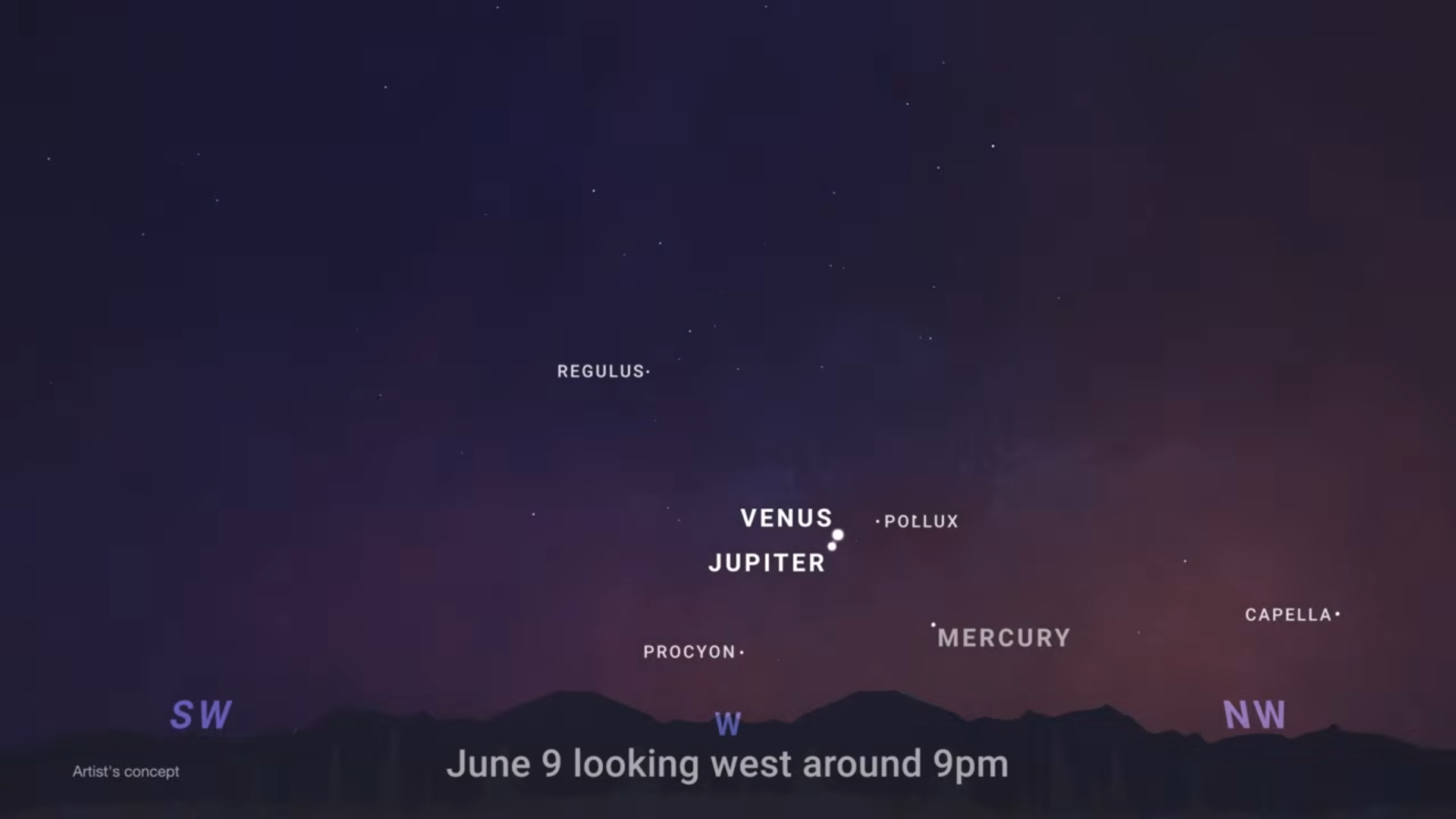
- June 9: Venus and Jupiter conjunction
- June 11–15: Mercury joins Venus and Jupiter after sunset
- June 17: Moon passes in front of Venus & close Moon and Venus pairing
- June 21: June solstice & start of astronomical summer
- June: Summer Triangle and deep-sky observing targets rise into view
Look Up!
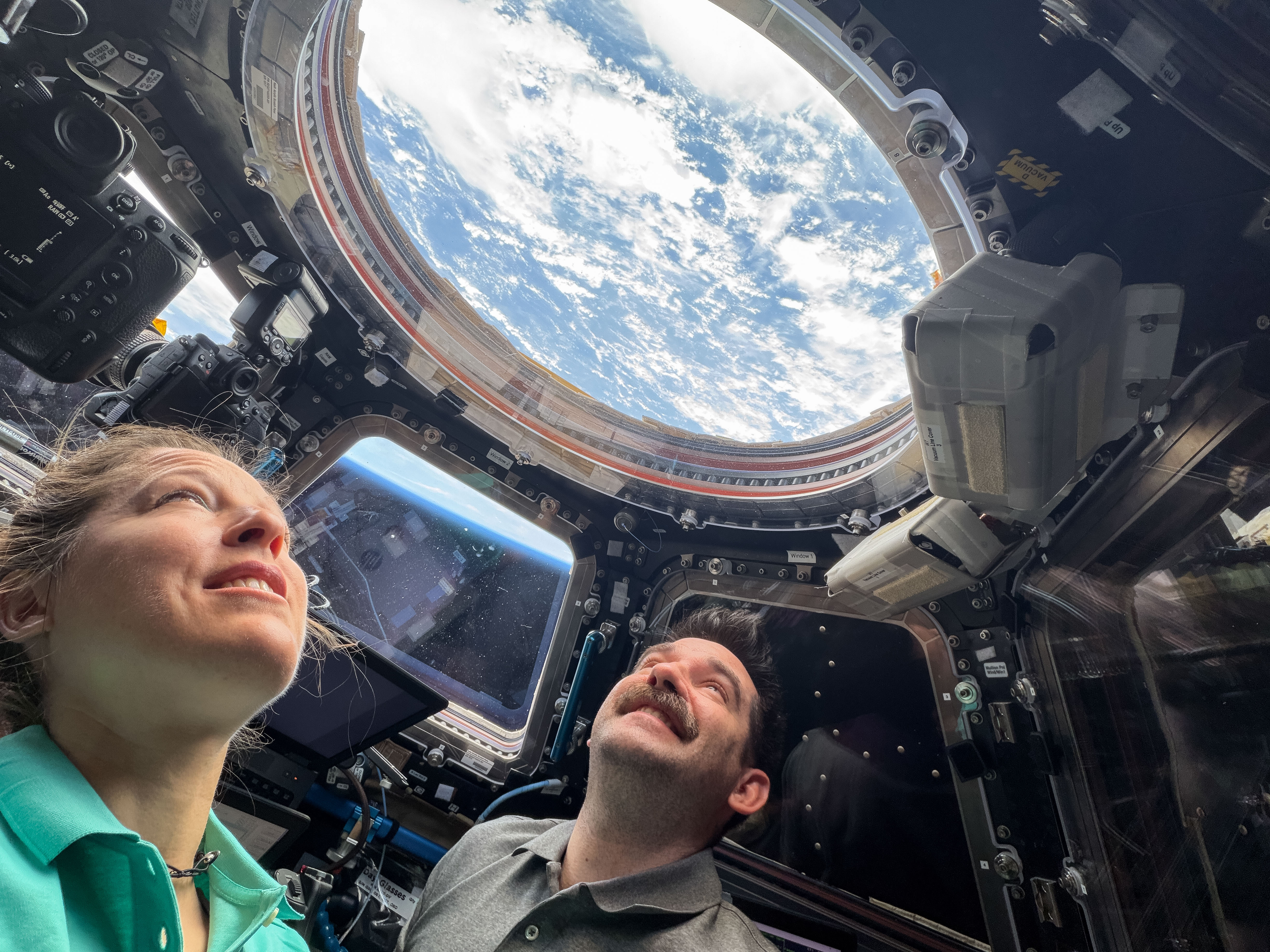
Astronauts Sophie Adenot of ESA (European Space Agency) and Jack Hathaway of NASA, both Expedition 74 flight engineers, look out a window in the cupola, monitoring the automated approach and docking of the SpaceX Dragon cargo spacecraft to the International Space Station on May 17, 2026. The orbital outpost was soaring 259 miles above the […]https://www.nasa.gov/image-article/look-up/
Look Up!
ESA/Sophie Adenot
Astronauts Sophie Adenot of ESA (European Space Agency) and Jack Hathaway of NASA, both Expedition 74 flight engineers, look out a window in the cupola, monitoring the automated approach and docking of the SpaceX Dragon cargo spacecraft to the International Space Station on May 17, 2026. The orbital outpost was soaring 259 miles above the Indian Ocean just west of the Maldives at the time of this photograph.
See the cupola and other parts of the space station in our guided tour.
Image credit: ESA/Sophie Adenot
https://www.nasa.gov/image-article/look-up/
NASA Testing Wastewater Treatment Facility for Future Moon Base
A mobile wastewater treatment system built at NASA’s Kennedy Space Center in Florida that can help prepare for long-duration missions on the Moon and Mars departed the spaceport and arrived at the University of North Dakota in Grand Forks. Graduate students at the university will test the technology under conditions designed to closely mimic the […]https://www.nasa.gov/centers-and-facilities/kennedy/nasa-testing-wastewater-treatment-facility-for-future-moon-base/
NASA Testing Wastewater Treatment Facility for Future Moon Base

Technicians prepare the Divergent Deployable Wastewater Treatment Facility, designed to turn crew wastewater into useful resources, for transport at NASA’s Kennedy Space Center in Florida on Tuesday, April 21, 2026.
NASA/Kim Shiflett
A mobile wastewater treatment system built at NASA’s Kennedy Space Center in Florida that can help prepare for long-duration missions on the Moon and Mars departed the spaceport and arrived at the University of North Dakota in Grand Forks. Graduate students at the university will test the technology under conditions designed to closely mimic the challenges of operating on another planetary surface.
The Divergent Deployable Wastewater Treatment Facility is designed to turn crew wastewater into useful resources, which future explorers will need every day. At the University of North Dakota, teams will integrate this new wastewater system with the university’s Integrated Lunar/Martian Analog Habitat. Student operators and NASA researchers will study how the facility performs when connected to a habitat-like environment and exposed to the kinds of operational limits crews could face on another planet.
“NASA’s Artemis program is laying the groundwork for a sustained human presence on the Moon, where habitats will need to operate far from the steady resupply chain that supports astronauts in partial gravity,” said Luke Roberson, surface water systems lead within the Mars Campaign Office at NASA Kennedy. “To solve that challenge, we are developing the future of sustainable lunar surface systems to process wastewater into nutrient feedstocks for plants and biomanufacturing.”
How Treatment System Works
Housed inside an 8.5-by-24-foot trailer, the facility brings together three biological reactor systems, a vertical garden, water-polishing hardware, environmental monitoring, autonomous control software, and safety systems. The trailer was outfitted at NASA Kennedy to function as a deployable laboratory and to travel between at least two simulation test sites as the technology matures.
Unlike wastewater systems on Earth, this facility keeps waste streams separate. That divergent approach is important for small crews, because wastewater from four to eight people can be highly concentrated. Urine, hygiene water, laundry water, fecal waste, and food waste each contain different levels of salts, solids, carbon, nitrogen, phosphorus, and other compounds. Treating them separately allows each stream to be processed by the reactor best suited for the job.
To do that, the system uses three different bioreactors to treat waste streams. The Anaerobic Phototrophic Membrane Bioreactor processes fecal and food waste and converts it into a nutrient-rich wastewater that can support plant growth. The Suspended Aerobic Membrane Bioreactor processes urine and flush water. The Membrane Aerated Biological Reactor treats graywater from hygiene and laundry activities. Collectively, the bioreactors process nutrients to feed the facility’s vertical garden and prepare the water for reuse. Inside that garden, crops will grow hydroponically, or without using soil, by using nutrient solutions derived from the bioreactors. Researchers will compare crop performance with plants grown using standard hydroponic nutrients.
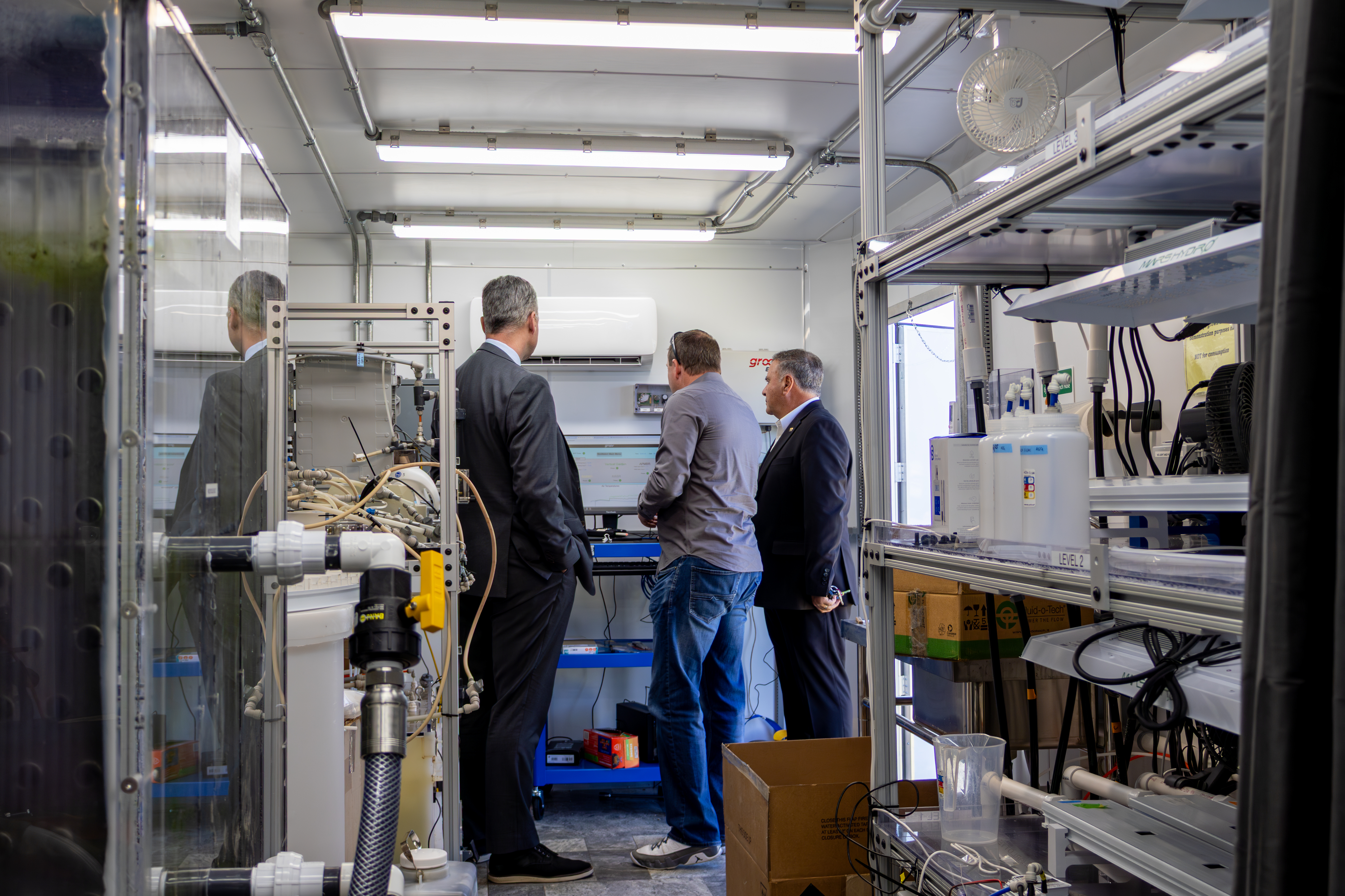
NASA’s Dr. Roberson demonstrating the Divergent Wastewater Treatment Facility to UND Chair Dr. De Leon and Dr. Robert Kraus, Dean of UND’s School of Aerospace Sciences.
University of North Dakota
At North Dakota, under a NASA EPSCoR (Established Program to Stimulate Competitive Research) grant, the facility was connected to the Integrated Lunar/Martian Analog Habitat through a bathroom interface that includes a urine-diverting toilet. The setup will allow different waste streams to be separated at the source and sent to the correct treatment systems. In parallel, Ali Alshami’s team is developing novel membrane-based separation technologies intended for future integration into the divergent wastewater facility to improve water recovery efficiency, contaminant rejection, and overall system resilience for long-duration habitation missions.
“The tests will help NASA evaluate real-world operation, crew training needs, system reliability, and how wastewater simulants compare with actual human metabolic waste in an analog mission environment,” said Alshami.
These efforts are focused on advancing compact, energy-efficient treatment approaches capable of handling complex wastewater streams generated in closed-loop extraterrestrial environments.
“The testing campaign at the University of North Dakota supports the facility’s technology maturation from laboratory-scale validation toward demonstration in a relevant Inflatable Lunar/Martian Analog Habitat environment,” said Pablo De Leon, professor and department chair of Space Studies at the University of North Dakota.
Lessons learned could inform future higher-fidelity tests, including potential integration with NASA’s next generation of yearlong simulated Mars missions via isolation analogs at the agency’s Johnson Space Center in Houston.
Technology for Making Moon Base Sustainable
The work is part of NASA’s broader Bioregenerative Life Support Systems effort, which is developing biological approaches to reduce dependence on Earth-supplied consumables. In future lunar or Martian habitats, systems like the wastewater treatment facility could help close life support loops by recovering water, recycling nutrients, supporting crop production, and reducing the amount of waste that must be stored or discarded. Further NASA research completed trade studies demonstrating how bioregenerative life support becomes more effective for space travel over current life support technologies.
NASA researchers also are exploring how wastewater-recovered resources could support in-space manufacturing. One effort is studying how nutrient-rich water from bioregenerative wastewater systems could feed microbes that produce lactic acid, which can be turned into polylactic acid. The material could one day serve as a binder for 3D printing with lunar or Martian regolith, the loose, fragmental surface material, or could be used for replacement parts, extending the value of recovered waste beyond water and food systems.
“By sending the facility from NASA Kennedy to North Dakota, the agency is moving a key part of that circular economy out of the lab and into a real-world test,” said J.J. Edelmann, surface systems domain lead for the Mars Campaign Office at NASA Headquarters in Washington. “The work may begin with wastewater, but its goal is much larger. We want to help future crews live sustainably on the Moon, learn how to operate farther from Earth, and carry those lessons forward to Mars.”
To learn more about the agency’s lunar and Mars exploration, visit:
https://www.nasa.gov/centers-and-facilities/kennedy/nasa-testing-wastewater-treatment-facility-for-future-moon-base/
Be a Clump Scout and Help Reveal Secrets of Stellar Nurseries
Help identify star-forming clumps in galaxy images, and help train machines to do the same.https://science.nasa.gov/get-involved/citizen-science/help-galaxy-zoo-clump-scout-ii-project/
Be a Clump Scout and Help Reveal Secrets of Stellar Nurseries
In the mid-20th century, astronomers discovered strange “clumpy” galaxies filled with mysterious bright blobs – massive stellar nurseries where stars are born at an explosive rate. Curiously, these clumpy galaxies were much more common in the early universe than they are today. We still don’t know why they vanished.
The Euclid space telescope, an ESA (European Space Agency) mission with critical contributions from NASA, has begun to capture images of millions of galaxies. These images – far more than any team of professional scientists could ever catalog alone – include high-definition views of clumpy galaxies that promise to reveal structure within and among the clumps. Astronomers hope to use these images to obtain new information about which galaxies host clumps, where the clumps are, how and why they evolved, and more – but they need your help!
To tackle this mountain of data, scientists are creating a “digital assistant” in the form of machine learning, a kind of artificial intelligence. The machine algorithm has been partially trained with results from an earlier project called “Galaxy Zoo: Clump Scout.” Now, as a volunteer for the new Galaxy Zoo: Clump Scout II project, you’ll improve and train this tool further. You’ll examine images of galaxies that the machine has labelled with squares where it thinks it sees a real clump. The machine often gets confused by distant stars or camera glitches. So you’ll gently move those squares around, delete them, or add new ones, to help the algorithm learn.
As a part of Galaxy Zoo: Clump Scout II, you will help investigate how giant star-forming nurseries formed, solve the mystery of their disappearance over cosmic time, and reveal more about how star formation really works in galaxies. All you need is a laptop or smartphone. Click here to learn more!
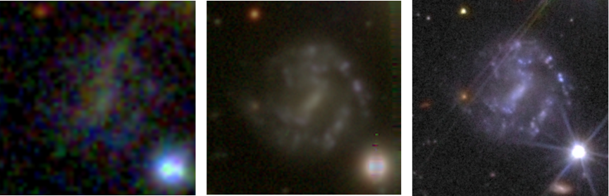
A clumpy galaxy seen by telescopes with the Sloan Digital Sky Survey (left), the Hyper Suprime-Cam (middle) and the Euclid mission (right). You can see how the better resolving power of each subsequent telescope helps us see more and more detail about the star-forming clumps. (The bright object at the bottom right is a foreground star.)
Image data: SDSS (left; Sloan Digital Sky Survey – CC BY 4.0); HSC (center; NAOJ/HSC Project – CC BY 4.0); Euclid (right; ESA/Euclid/Euclid Consortium/NASA – CC BY 3.0 IGO). Image post-processing and compilation by Hugh Dickinson and Jürgen Popp.
https://science.nasa.gov/get-involved/citizen-science/help-galaxy-zoo-clump-scout-ii-project/
Spacewalking With Scott Wray, Artemis EVA Training Lead
Scott Wray’s experience with spacewalks started when he was about 6 years old. A tent resembling a lunar lander provided the perfect imaginary spacecraft. “I would lie on my back with my feet propped up on a pillow as I imagined going through a launch countdown sequence,” he said. “Then I would exit the tent […]https://www.nasa.gov/centers-and-facilities/johnson/spacewalking-with-scott-wray-artemis-eva-training-lead/
Spacewalking With Scott Wray, Artemis EVA Training Lead
6 Min Read
Spacewalking With Scott Wray, Artemis EVA Training Lead
Credits:
NASA/Bill Brassard
Scott Wray’s experience with spacewalks started when he was about 6 years old. A tent resembling a lunar lander provided the perfect imaginary spacecraft. “I would lie on my back with my feet propped up on a pillow as I imagined going through a launch countdown sequence,” he said. “Then I would exit the tent into a darkened bedroom and hop around just like the footage I had seen of Apollo astronauts.”
Today, with more than 16 years at NASA’s Johnson Space Center under his belt, Wray is proud to have shaped spacewalk training across three eras of human spaceflight.
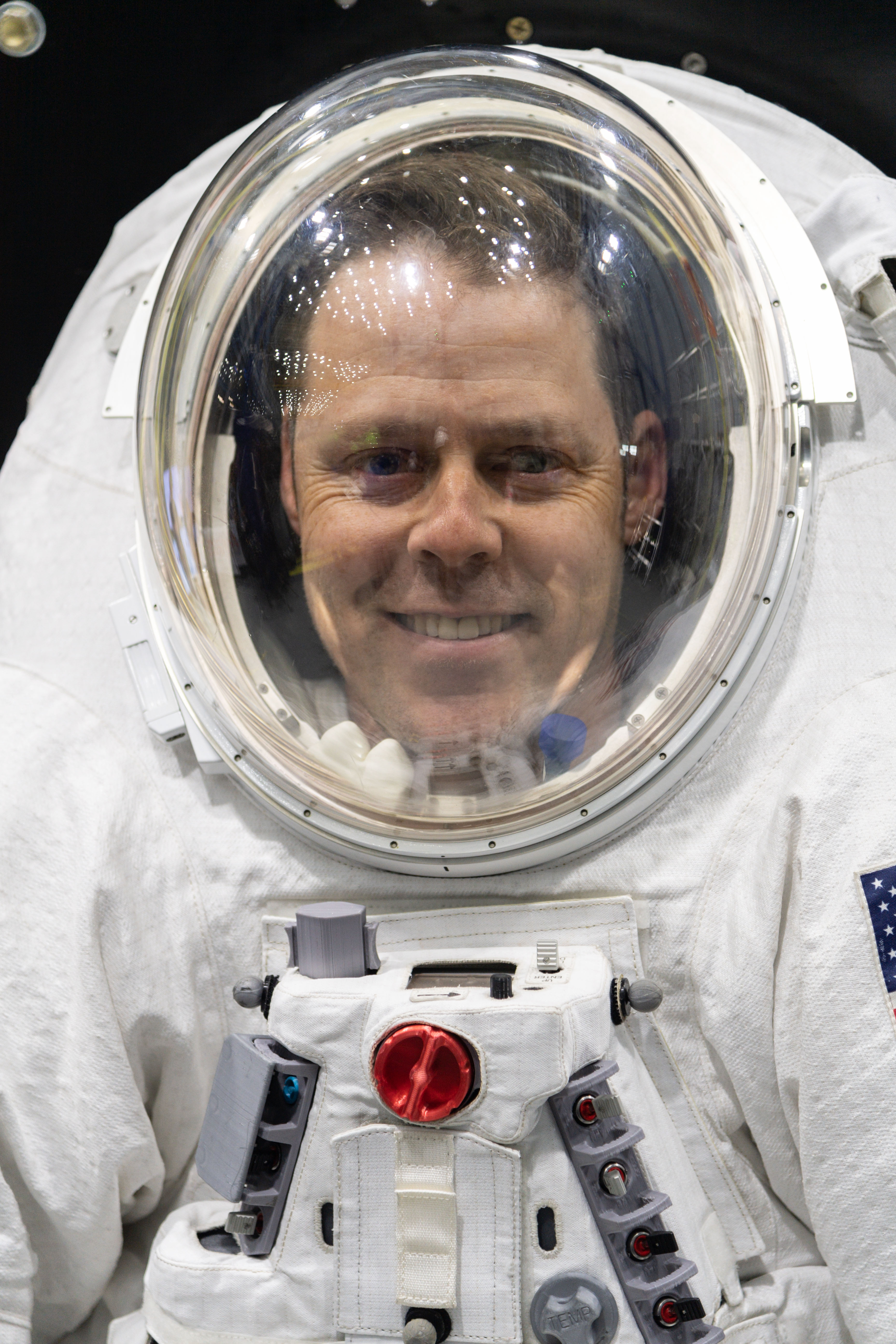
Scott Wray smiles before a suited test run with Johnson’s Active Response Gravity Offload System.
NASA/Josh Valcarcel
The childhood fascination with spaceflight evolved into a passion for engineering, demonstrated through countless LEGO and airplane model builds and voracious readership of aircraft design books. His path to NASA was cemented by a week-long camp at Space Center Houston, which included several tours of Johnson’s signature facilities and a visit by former NASA Flight Director Gene Kranz. “I was so inspired by the facilities and the incredible history of this place, I knew that I had to work here someday,” he said.
Wray participated in NASA’s Contractor Co-op Program with United Space Alliance while studying aerospace engineering at Embry-Riddle Aeronautical University and completed several tours with different organizations at Johnson. At the time, astronauts were training to conduct spacewalks, also known as EVAs, for both the Space Shuttle and International Space Station programs. During one co-op experience with the shuttle’s In-Flight Maintenance Team (IFM), Wray observed the IFM and EVA teams collaborating with the STS-117 crew to fix the peeled-back thermal blanket on space shuttle Atlantis’s Orbital Maneuvering System pod. He helped the teams develop crew procedures for practicing the repair inside the shuttle, using surgical staples and pins to tack the blanket down. “This real-time troubleshooting is where I learned about the EVA group and set my sights on working there during my final co-op tour,” he said. “I love to be hands-on, to take things apart and come up with creative solutions – that’s what really attracted me to EVA.”
EVA work also reminded Wray of time spent as a dog mushing guide in Alaska. “That is where I got my first taste of expeditionary skills,” he said. “We lived in a remote glacier camp, taking care of 250 Alaskan Huskies. I learned how to make do with the tools you have and make repairs to a broken sled miles away from home.” At times, Johnson’s EVA team must create similar workarounds. “Some of our best moments as a team have come when our hardware or vehicle has malfunctioned, requiring us to devise a real-time solution,” he said. “It sounds scrappy, but I think it’s how we put the human into human spaceflight.”
Wray became a full-time EVA team member at Johnson after graduation, working under various contracts until he transitioned to a civil servant position in 2021. He started as an EVA instructor focused on tools and hardware and teaching astronauts how to perform their maintenance and repair duties. As NASA’s astronaut corps evolved to include a wider range of backgrounds and body types, Wray worked to develop new EVA techniques and tools that could accommodate any crew member. “That meant creating a curriculum that capitalized on individual strengths while building teamwork and resilience,” he said.
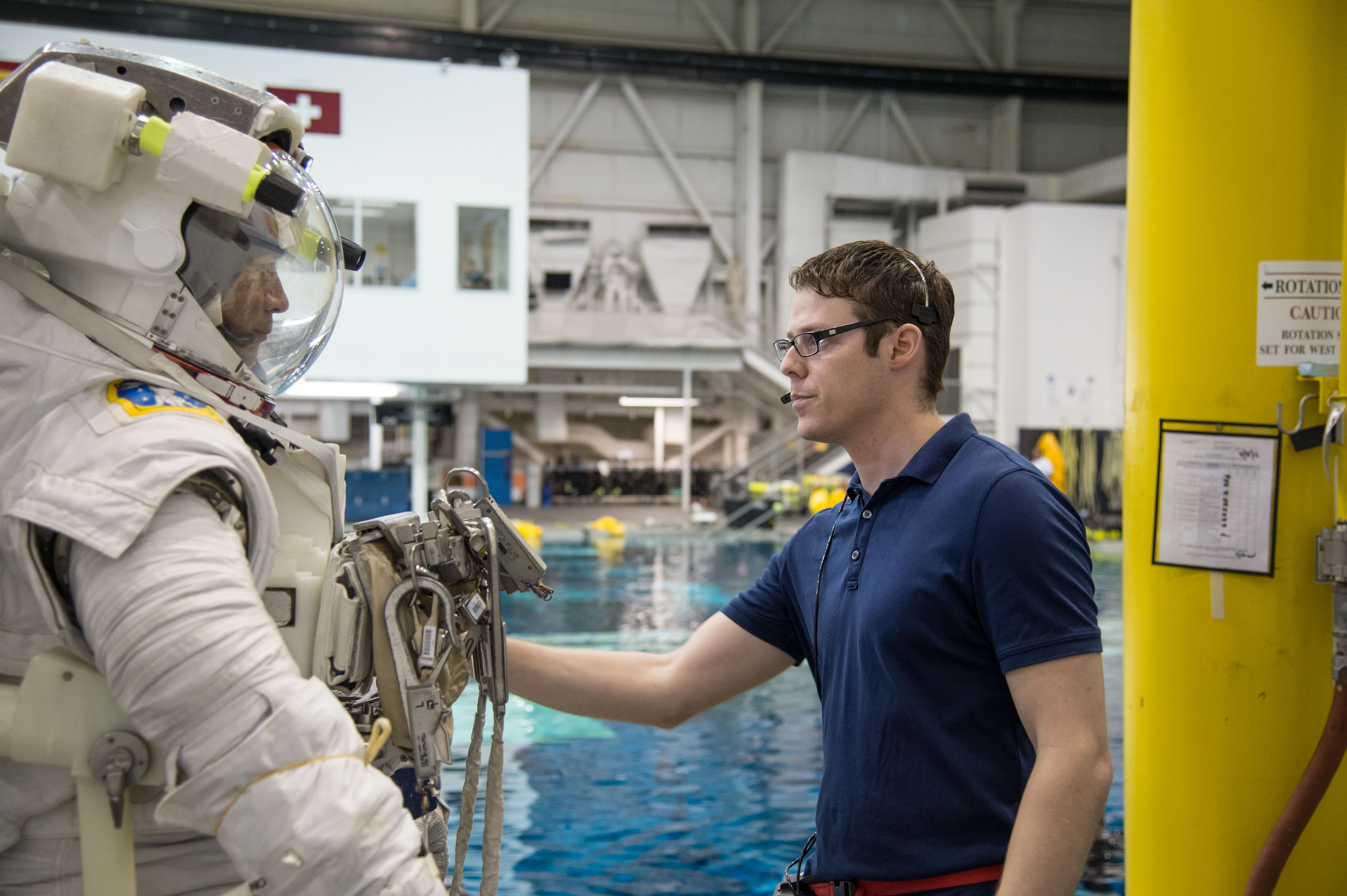
Scott Wray prepares JAXA (Japan Aerospace Exploration Agency) astronaut Kimiya Yui for an EVA training run in the Neutral Buoyancy Laboratory pool.
NASA/Bill Stafford
Wray also served as a flight controller for shuttle and space station EVAs. He remembers being on console in Johnson’s Mission Control Center during a space station EVA in July 2013. That excursion was terminated early after water began filling the spacesuit helmet of ESA (European Space Agency) astronaut Luca Parmitano, and the team could neither determine its source nor stop its flow. “That incident taught me that even after decades of operating a spacesuit, there are still failure modes we haven’t imagined,” he said. “It reinforced the need for vigilance, adaptability, and continuous learning—because in human spaceflight, lives depend on it.”
In the last few years, Wray’s responsibilities shifted to preparing Artemis crew members for missions to the Moon. Now the Artemis EVA training lead, Wray oversees the development of training flows that will ready astronauts for lunar surface operations – a challenge NASA has not faced in over 50 years.
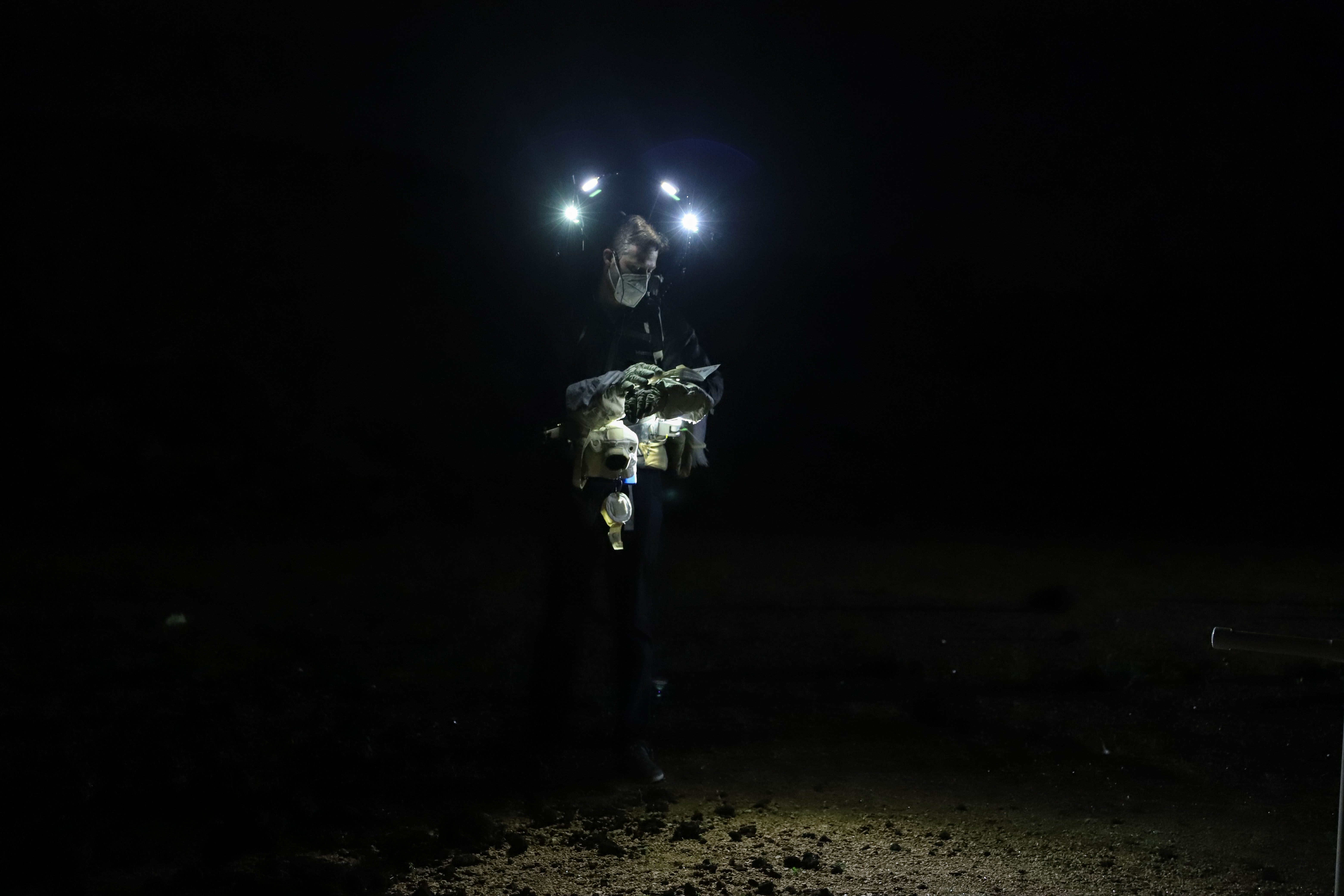
Scott Wray participates in a nighttime evaluation of EVA operations at the Johnson Space Center Rock Yard in March 2021. The evening test was designed to better understand the impact of lunar South Pole lighting conditions on EVA operations.
While many astronauts have completed space station training or an EVA, the skills required for lunar exploration will be different. “It’s going to be a completely new spacesuit, new vehicles, new environment,” Wray said. “And now they’re going to be walking instead of translating with their hands like we do on station.” At the same time, trainings must go beyond these foundational spacewalk techniques. “Our curriculum integrates geology, covering topics like impact cratering, volcanology, sample collection, and traverse planning,” Wray explained. “It’s about enabling astronauts to become effective field scientists while mastering complex EVA operations.”
To build these skills, the team uses multiple training environments. The Neutral Buoyancy Laboratory has been NASA’s flagship EVA training facility since it opened in 1997, but the team also uses the Active Response Gravity Offload System for suited mobility practice. Additional training systems include virtual reality, lighting laboratories that simulate the Moon’s harsh South Pole lighting conditions, field sites for geology training and sample collection, and suit simulators that prepare astronauts to respond to caution-and-warning scenarios.
“Spearheading this effort as EVA training lead allows me to ensure every element—from science to operations—is integrated into a program that will prepare astronauts for success on the Moon and beyond,” Wray said. “This effort is more than preparation, it’s the foundation for future exploration and a steppingstone toward Mars. Knowing that our work will help shape the next era of human spaceflight is incredibly rewarding.”
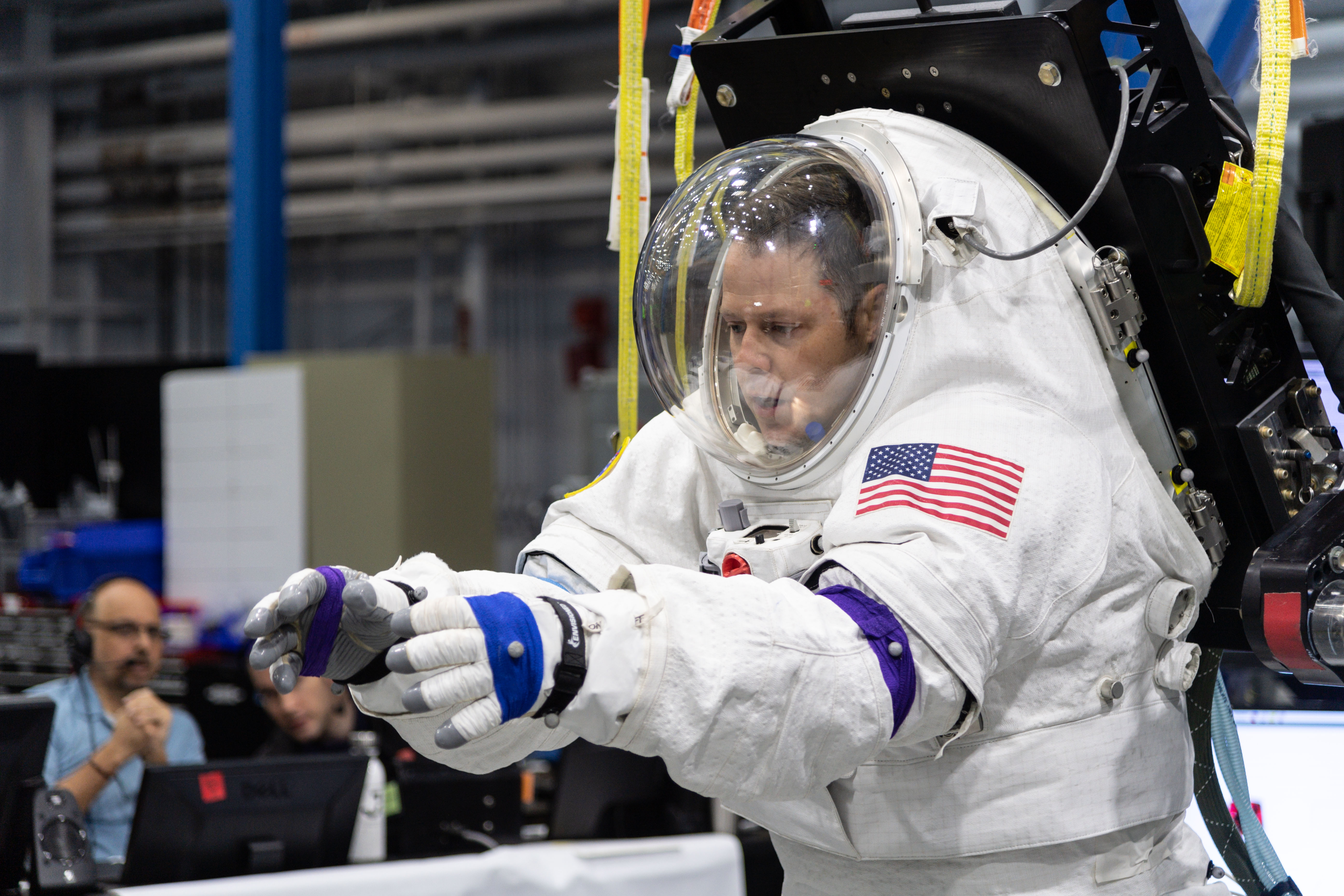
Scott Wray serves as the test subject for Exploration EVA Pressure Garment Subsystem mobility data collection using the Active Response Gravity Offload System.
Amid these complex preparations, Wray still finds time for new pursuits outside of the office. His daughter inspired him and his wife to try an acting class at a local fine arts studio, leading to Wray’s on-stage debut in a performance of “Rock of Ages.” He starred as William Shakespeare in this year’s production of “Something Rotten.” “I never would have thought I’d have so much fun acting, singing, and dancing on stage,” he said. “The community we are part of and the ability to join our daughter in activities she enjoys has been so rewarding.”
Wray said he is incredibly grateful to play another role off-stage – being part of missions that will conduct meaningful science on the lunar surface. “Returning to the Moon is something I’ve dreamed about since I was a kid,” he said. “Artemis isn’t just about going back—it’s about shaping the future. When we choose to push the boundaries of exploration, the advancements we make don’t just expand knowledge, they create lasting benefits for all of humanity.”
About the Author
Linda E. Grimm
Details
Last Updated
May 28, 2026
Related Terms
Explore More
Keep Exploring
Discover More Topics From NASA


https://www.nasa.gov/centers-and-facilities/johnson/spacewalking-with-scott-wray-artemis-eva-training-lead/
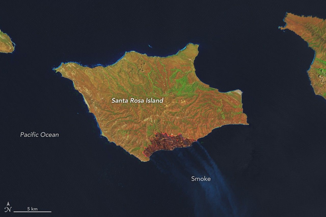
Fire’s Footprint on Santa Rosa Island
A wildland fire charred grassland, coastal sage scrub, and chaparral across one-third of the island, the second largest of the Channel Islands.https://science.nasa.gov/earth/earth-observatory/fires-footprint-on-santa-rosa-island/
Fire’s Footprint on Santa Rosa Island

May 16, 2026
May 24, 2026

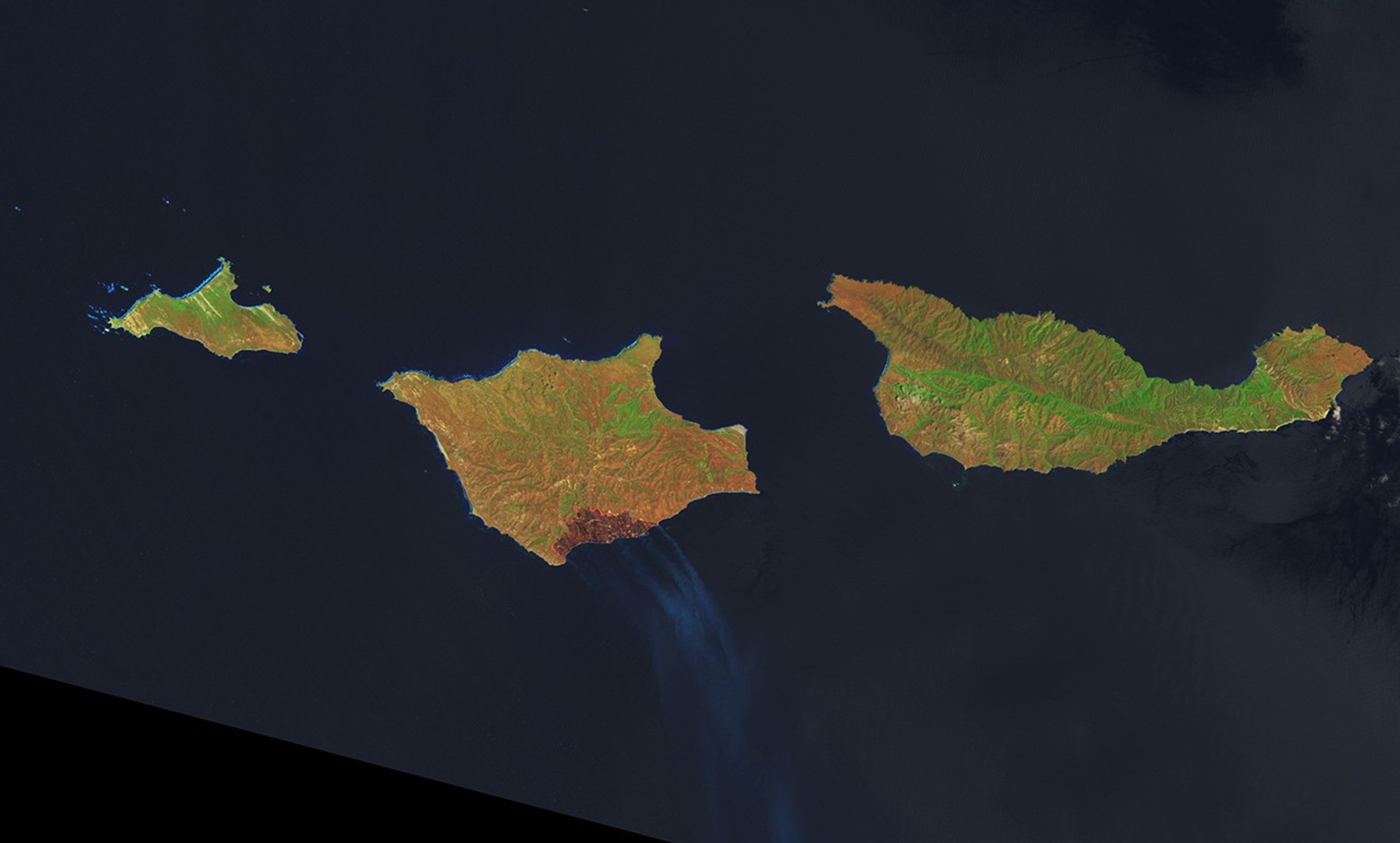
A false-color image of Santa Rosa Island from May 16, 2026, shows a dark-brown burned area toward the bottom-right. A thin, bright orange line runs along the burned area, indicating the active fire front.
NASA Earth Observatory / Lauren Dauphin
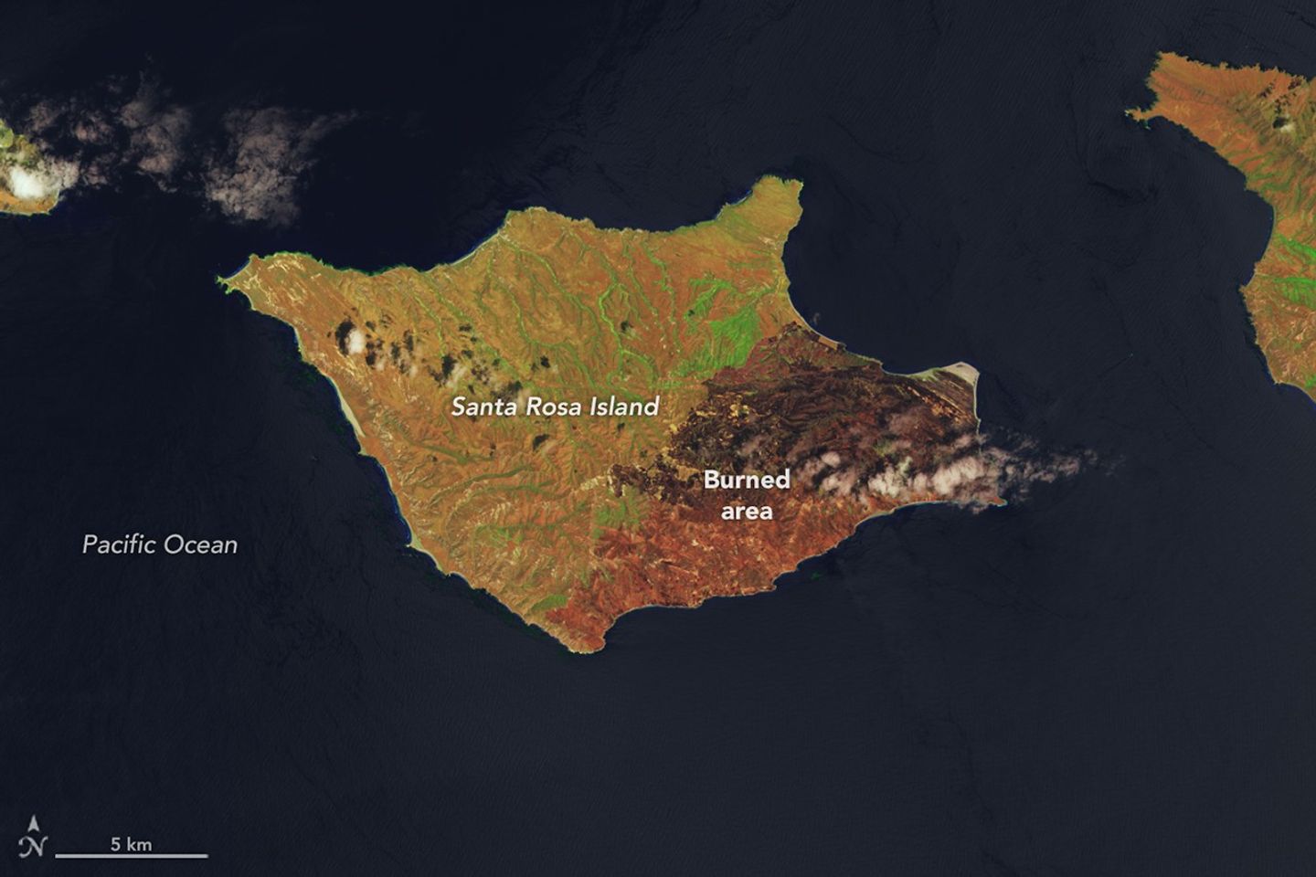
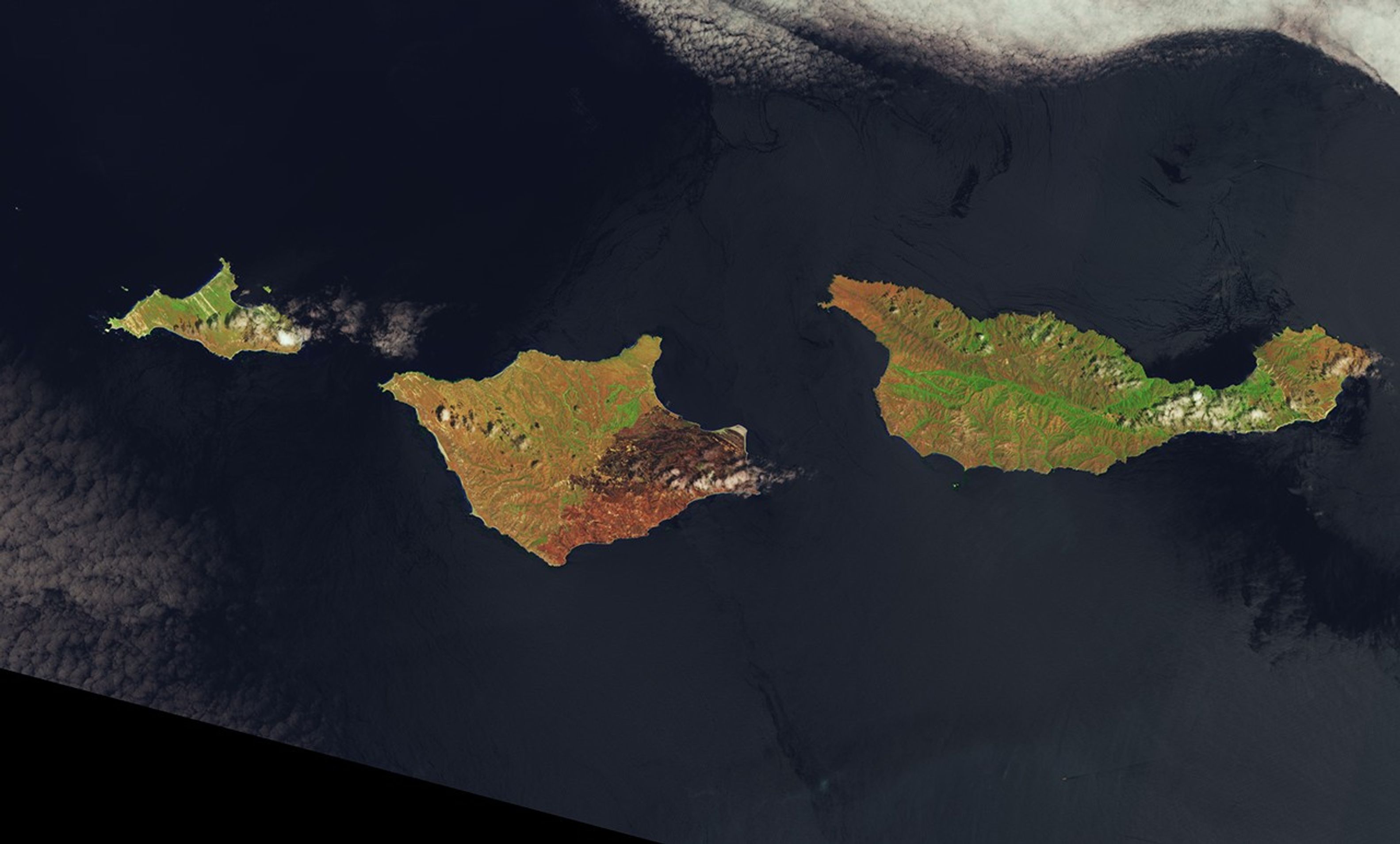
A false-color image of Santa Rosa Island from May 24, 2026, shows a reddish-brown burned area spanning the eastern third of the island.
NASA Earth Observatory / Lauren Dauphin
A false-color image of Santa Rosa Island from May 16, 2026, shows a dark-brown burned area toward the bottom-right. A thin, bright orange line runs along the burned area, indicating the active fire front.
NASA Earth Observatory / Lauren Dauphin
A false-color image of Santa Rosa Island from May 24, 2026, shows a reddish-brown burned area spanning the eastern third of the island.
NASA Earth Observatory / Lauren Dauphin
May 16, 2026
May 24, 2026
On May 15, 2026, a fire was spotted from aircraft on the southeastern side of Santa Rosa Island, part of California’s Channel Islands National Park. The blaze spread over the next several days, ultimately burning 18,379 acres (7,438 hectares)—about one-third of the island.
These images show the expansion of the fire’s burned area between May 16 (left), the day after it was discovered, and May 24 (right), after the fire’s growth had stabilized. The Landsat satellite images are false-color to help distinguish burned areas (brown) from healthy vegetation (green). Officials reported the fire was 97 percent contained by the evening of May 26.
NASA tools utilizing satellite observations, namely FIRMS (Fire Information for Resource Management System) and the Fire Event Explorer, show how the fire spread to the north and east over several days. As it advanced, it consumed areas of grassland, coastal sage scrub, and island chaparral.
Santa Rosa Island, like the other Channel Islands, is known for its diversity of plant and animal species, some of them rare. Observers were concerned that the fire threatened the island’s Torrey pines, a rare type of tree that in the United States grows naturally only on the northeastern coast of Santa Rosa Island and near San Diego.
Initial post-fire surveys by firefighters and unmanned aircraft indicated the Torrey pine stand remained largely intact. The fire mostly burned at lower intensity through the pine areas and spared the canopy. However, some pockets of forest sustained damage where intensity was higher. Along the northwest edge of the fire, suppression crews worked to protect another vulnerable area—the cloud forests—by cooling fuels ahead of the fire’s front.
Local reports suggest the Santa Rosa Island fire is the largest on record on any of California’s Channel Islands. Some of the islands’ chaparral and tree species are adapted to fire but less dependent on it than their mainland counterparts, according to the National Park Service, because naturally occurring fire is less frequent on the Channel Islands.
NASA Earth Observatory images by Lauren Dauphin, using Landsat data from the U.S. Geological Survey. Story by Lindsey Doermann.
References & Resources
You may also be interested in:
Stay up-to-date with the latest content from NASA as we explore the universe and discover more about our home planet.

Fire Chars Santa Rosa Island
2 min read
The blaze spread across the southern side of the second-largest island in California’s Channel Islands National Park.
Article

Fires Tear Through Nebraska Grasslands
3 min read
Dry, warm, and windy conditions across the U.S. Great Plains led to extreme fire activity in March 2026.
Article

Smoke Rises Over Big Cypress National Preserve
2 min read
The National fire has burned tens of thousands of acres within the Florida preserve, fueled by vegetation dried by prolonged…
Article
Keep Exploring
Discover More from NASA Earth Science
Subscribe to Earth Observatory Newsletters
Subscribe to the Earth Observatory and get the Earth in your inbox.
Earth Observatory Image of the Day
NASA’s Earth Observatory brings you the Earth, every day, with in-depth stories and stunning imagery.

Explore Earth Science

Earth Science Data
Open access to NASA’s archive of Earth science data

https://science.nasa.gov/earth/earth-observatory/fires-footprint-on-santa-rosa-island/
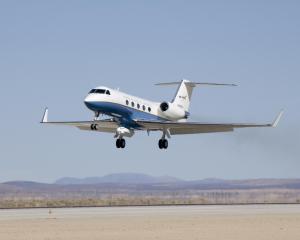
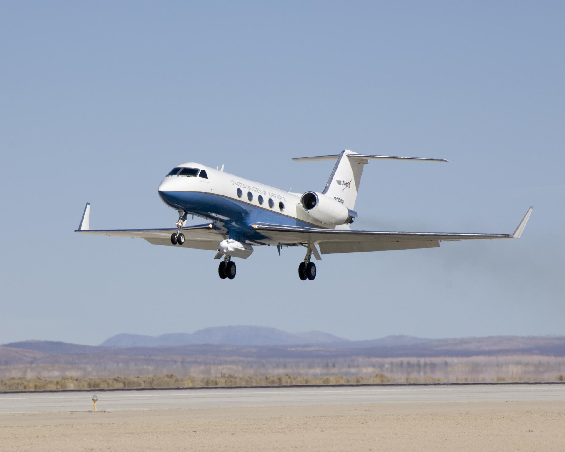
NASA Awards Modification Contract for Reduced Gravity Test Aircraft
NASA selected Denmar Technical Services of Nevada to provide aircraft modifications, maintenance, and testing services to the Human Spaceflight Mission Directorate at NASA’s Armstrong Flight Research Center in Edwards, California, and Johnson Space Center in Houston. The award is a firm-fixed-price contract and will be time and material for any over and above and unforeseen […]https://www.nasa.gov/news-release/nasa-awards-modification-contract-for-reduced-gravity-test-aircraft/
NASA Awards Modification Contract for Reduced Gravity Test Aircraft
1 min read
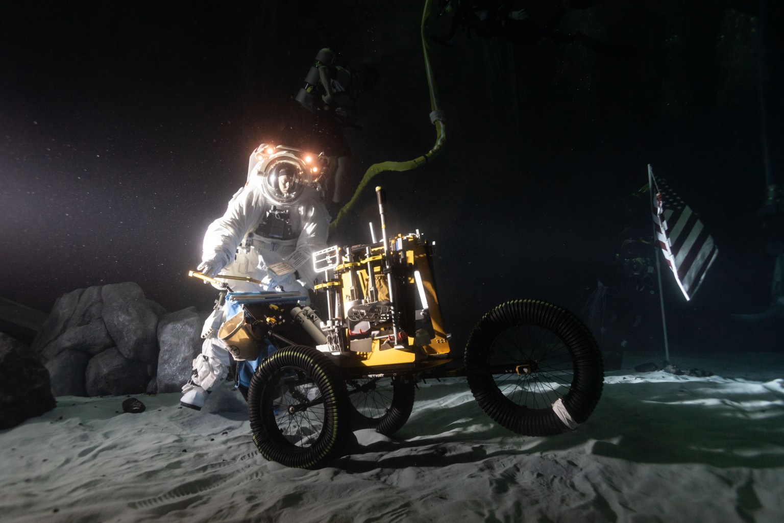
Preparations for Next Moonwalk Simulations Underway (and Underwater)
NASA
NASA selected Denmar Technical Services of Nevada to provide aircraft modifications, maintenance, and testing services to the Human Spaceflight Mission Directorate at NASA’s Armstrong Flight Research Center in Edwards, California, and Johnson Space Center in Houston.
The award is a firm-fixed-price contract and will be time and material for any over and above and unforeseen work. This contract has a maximum potential value of $8.4 million, which runs through Feb. 1, 2027.
The contractor will modify a Boeing 737-700 aircraft to perform lunar-gravity parabolic flights to test NASA space equipment. Once modifications are complete, NASA Armstrong will own the aircraft and oversee aircraft operations out of NASA Johnson.
The aircraft will be used to validate astronaut lunar suits and associated crew systems required to support Artemis mission objectives. This can be done with the modified 737 aircraft in an operationally relevant, reduced-gravity environment prior to lunar mission execution.
For information about NASA and agency programs, visit:
-end-
Dede Dinius
Armstrong Flight Research Center, Edwards, Calif.
661-276-5701
darin.l.dinius@nasa.gov
Details
Last Updated
Jun 01, 2026
Related Terms
https://www.nasa.gov/news-release/nasa-awards-modification-contract-for-reduced-gravity-test-aircraft/
NASA Invites Media to See Roman Space Telescope Arrive at Kennedy
Registration is open for media to cover the arrival of NASA’s Nancy Grace Roman Space Telescope at the agency’s Kennedy Space Center in Florida in the coming weeks. The observatory will arrive aboard NASA’s Pegasus barge from NASA’s Goddard Space Flight Center in Greenbelt, Maryland, where teams completed its construction, assembly, and testing. Credentialed media […]https://www.nasa.gov/news-release/nasa-invites-media-to-see-roman-space-telescope-arrive-at-kennedy/
NASA Invites Media to See Roman Space Telescope Arrive at Kennedy
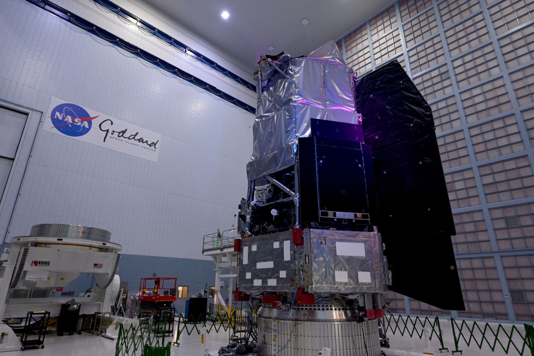
NASA’s Nancy Grace Roman Space Telescope stands complete in the largest clean room at the agency’s Goddard Space Flight Center in Greenbelt, Maryland. With its deep, sweeping views of the universe, Roman will observe billions of cosmic objects to explore fundamental questions about dark energy and planets outside our solar system.
Credit: NASA/Scott Wiessinger
Registration is open for media to cover the arrival of NASA’s Nancy Grace Roman Space Telescope at the agency’s Kennedy Space Center in Florida in the coming weeks.
The observatory will arrive aboard NASA’s Pegasus barge from NASA’s Goddard Space Flight Center in Greenbelt, Maryland, where teams completed its construction, assembly, and testing. Credentialed media will be able to witness the arrival and unloading of the space telescope in its transport container at NASA Kennedy’s turn basin. From there, technicians will move the telescope to the center’s Payload Hazardous Servicing Facility for launch processing.
NASA subject matter experts will be available on site to answer questions about the arrival.
Media interested in participating must apply for credentials at:
To receive credentials, media must apply by 11:59 p.m. EDT on Thursday, June 4. This opportunity is open to U.S. citizens only.
Once approved, credentialed media will receive a confirmation email. Additional information, including the specific date of arrival activities, will follow. NASA’s media accreditation policy is available online. For questions about accreditation, please email ksc-media-accreditat@mail.nasa.gov. For other questions, please contact Kennedy’s newsroom at: 321-867-2468.
Named after NASA’s first chief astronomer, the Nancy Grace Roman Space Telescope will have a deep, panoramic view of the cosmos, generating never-before-seen pictures that will revolutionize our understanding of the universe. The observatory will usher in a new era of cosmic surveys, unveiling troves of celestial objects, and shedding light on some of the universe’s most profound mysteries, including phenomena we can’t see. Roman also will showcase a test of the most advanced technology ever flown in space to directly image planets around nearby stars, a key step in NASA’s search for life on other worlds.
The Roman telescope is managed at NASA Goddard with participation by NASA’s Jet Propulsion Laboratory in Southern California; Caltech/IPAC in Pasadena, California; the Space Telescope Science Institute in Baltimore; and a science team of scientists from various research institutions. The primary industrial partners are BAE Systems Inc., L3Harris Technologies, and Teledyne Scientific & Imaging. Contributions to Roman also are made by ESA (European Space Agency), JAXA (Japan Aerospace Exploration Agency), the French space agency CNES (Centre National d’Études Spatiales), and the Max Planck Institute for Astronomy in Germany.
The agency’s Launch Services Program, based at NASA Kennedy, manages the launch service for the Roman Space Telescope, which will lift off as soon as early September on a SpaceX Falcon Heavy rocket from Launch Complex 39A.
For more information about NASA’s Roman telescope, visit:
-end-
Karen Fox / Alise Fisher
Headquarters, Washington
202-385-1287 / 202-358-2546
karen.c.fox@nasa.gov / alise.m.fisher@nasa.gov
Leejay Lockhart / Danielle Sempsrott
Kennedy Space Center, Fla.
321-747-8310 / 321-298-8990
leejay.lockhart@nasa.gov / danielle.c.sempsrott@nasa.gov
Claire Andreoli
Goddard Space Flight Center, Greenbelt, Md.
301-286-1940
claire.andreoli@nasa.gov
https://www.nasa.gov/news-release/nasa-invites-media-to-see-roman-space-telescope-arrive-at-kennedy/
NASA to Conduct Low-Altitude Flights Near Houston
Five research aircraft will support a Student Airborne Research Program (SARP) mission out of Ellington Field in Houston. Flights are expected from Wednesday, June 3 to Saturday, June 13. During the mission, select maneuvers will be conducted at low altitudes over the Houston area. Pilots will fly remote sensing payloads in raster patterns, or parallel back-and-forth lines. The instruments flown could help […]https://www.nasa.gov/general/nasa-to-conduct-low-altitude-flights-near-houston/
NASA to Conduct Low-Altitude Flights Near Houston
NASA’s C-20A research aircraft takes off from the Edwards Air Force Base runway on an envelope-expansion flight test with the unmanned aerial vehicle synthetic aperture radar pod.
NASA/Tony Landis
Five research aircraft will support a Student Airborne Research Program (SARP) mission out of Ellington Field in Houston. Flights are expected from Wednesday, June 3 to Saturday, June 13. During the mission, select maneuvers will be conducted at low altitudes over the Houston area.
Pilots will fly remote sensing payloads in raster patterns, or parallel back-and-forth lines. The instruments flown could help researchers map the movement of the gases and particles that make up Earth’s atmosphere, changes to the lowest part of the atmosphere near the coastline, and the natural processes affecting the land and water in that area. The flights will primarily take place in the Houston area, with some extending over the Gulf of America.
While many of the flights will operate at higher altitudes, a WP-3D Orion will conduct maneuvers as low as 1,000 feet above ground level. Owned and operated by the National Oceanic and Atmospheric Administration (NOAA), this aircraft is used as a hurricane hunter and has supported several airborne science missions for NASA. It is equipped with a multitude of scientific instrumentation, radars, and recording systems for both in-flight and remote sensing measurements of the atmosphere, the Earth, and its environment.
The NASA-operated aircraft participating in the mission also are equipped with a variety of remote sensing instruments, including two lidars, a synthetic-aperture radar, an imaging spectrometer, and two spectrometers.
The operations will involve the agency’s Gulfstream V (N95NA), Gulfstream C-20A (N802NA), and Gulfstream III (N520NA), as well as NOAA’s WP-3D Orion (N43RF) and a King Air B200 aircraft (N46L) owned by Dynamic Aviation and contracted by NASA. The flights can be tracked in real time at NASA Airborne Science Program Tracker.
The SARP effort is an eight-week summer internship program that provides undergraduate students with hands-on experience by engaging in field research and data analysis and with access to one or more NASA Airborne Science Program flying science laboratories.
For more information about the NASA Airborne Science program, visit:
https://airbornescience.nasa.gov
Explore More

https://www.nasa.gov/general/nasa-to-conduct-low-altitude-flights-near-houston/
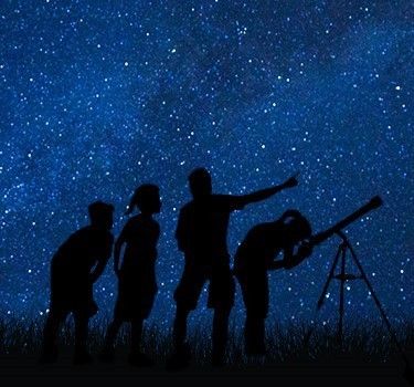
What’s Up: June 2026 Skywatching Tips from NASA
Venus and Jupiter meet after sunset, the Moon passes in front of Venus, summer begins, and deep-sky treasures rise into view.https://science.nasa.gov/solar-system/whats-up-june-2026-skywatching-tips-from-nasa/
What’s Up: June 2026 Skywatching Tips from NASA
Venus and Jupiter meet after sunset, the Moon passes in front of Venus, summer begins, and deep-sky treasures rise into view.
Skywatching Highlights
Transcript
Planets gather after sunset, the Moon passes in front of Venus, summer officially begins and deep sky treasures rise into view. That’s What’s Up for June.
Early this month, look west shortly after sunset to see Venus and Jupiter. They are two of the brightest planets in our sky and around June 9th, they’ll appear close together after sunset. This is called a planetary conjunction—when two planets appear near each other from our point of view on Earth, even though they’re still millions of miles apart in space.
NASA/JPL-Caltech
From June 11th through June 15th, Mercury joins the scene, creating a mini parade of planets low in the western sky. This happens because the planets orbit the sun along nearly the same path in our sky, called the ecliptic. So from our point of view on Earth, they sometimes appear to gather in the same part of the sky.
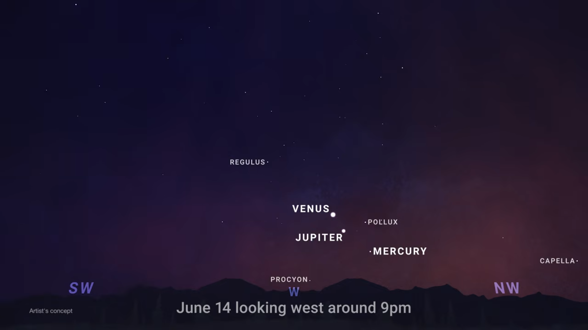
NASA/JPL-Caltech
Venus will be the brightest and easiest to spot with Jupiter nearby. Mercury will sit lower toward the horizon, so you will need a clear view to the west to catch it in the glow of twilight.
On June 17th, from some locations the Moon will pass in front of Venus. This is called a lunar occultation. For viewers in the right viewing path, Venus will look like it disappears behind the Moon, then reappears later. The event will be visible from parts of the United States, Canada, Brazil and Venezuela. Outside of the exact viewing path, many skywatchers may still see a close pairing of the Moon and Venus, but this comes with an important safety note. For many viewers this will happen during the daytime.
If you’re trying to observe the occultation, do not point binoculars, a telescope, or a camera near the sun unless you’re using proper solar safety equipment. Looking at or near the sun through optics can cause serious eye injury.
June also brings the summer solstice. In the Northern Hemisphere, the June solstice marks the start of the astronomical summer. In Pacific time, it happens on Sunday, June 21st at 1:24 a.m.
Around the solstice, the Northern Hemisphere gets its longest days and shortest nights of the year.
But here’s a fun fact, the longest day does not usually line up exactly with the earliest sunrise or latest sunset. For example, in Los Angeles, the earliest sunrise comes before the solstice, while the latest sunset comes after it.
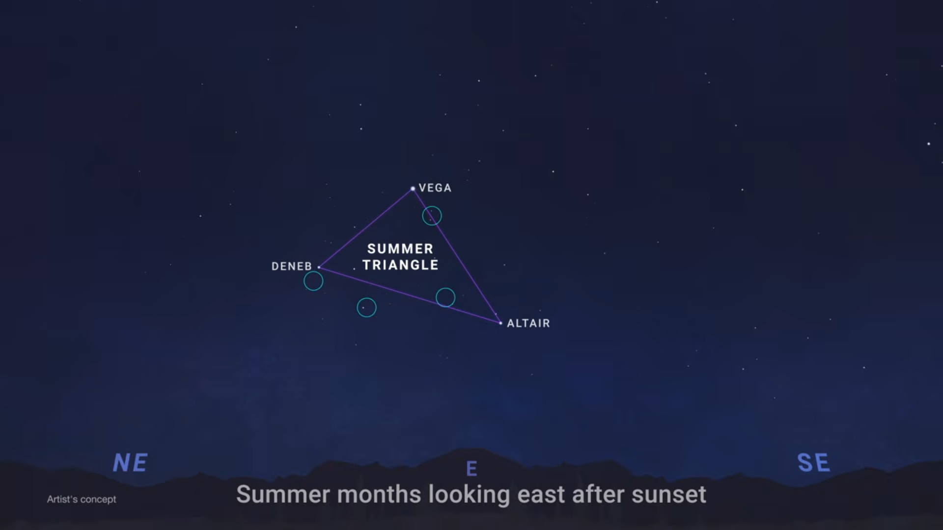
And once the sky gets dark, summer brings some favorite targets for telescope users and astrophotographers. First, look for the Summer Triangle, formed by the bright stars Vega, Altair, and Deneb. Inside and around this region are deep sky objects like the Dumbbell Nebula, the Ring Nebula, the North America Nebula, and the Veil Nebula. The Dumbbell Nebula, also known as Messier 27, was the first planetary nebula ever discovered.
These objects are not bright like planets, but with telescopes or long exposure photography, they reveal glowing gas, dying stars, and stellar nurseries in our galaxy.
NASA/JPL-Caltech
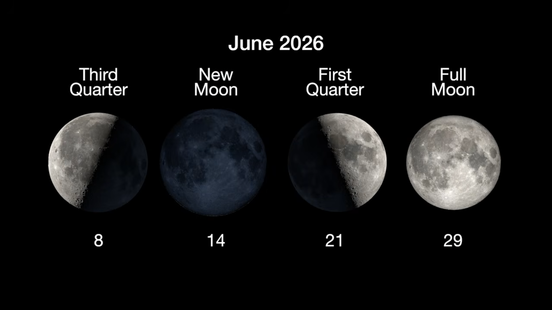
Here are the phases of the Moon for June. You can stay up to date on all of NASA’s missions exploring the solar system and beyond at science.nasa.gov. I’m Raquel Villanueva from NASA’s Jet Propulsion Laboratory, and that’s What’s Up this month.
NASA/JPL-Caltech
Keep Exploring
Discover More Topics From NASA

https://science.nasa.gov/solar-system/whats-up-june-2026-skywatching-tips-from-nasa/
Pretty in Pink
This image of Westerlund 2 released on March 19, 2026, features Chandra X-ray Observatory data (pink) and infrared data from NASA’S James Webb Space Telescope (red, orange, green, cyan, and blue). Scores of gleaming stars ringed in neon pink stretch across the frame, highlighting a cluster where stars are between one and three million years […]https://www.nasa.gov/image-article/pretty-in-pink-2/
Pretty in Pink

X-ray: NASA/CXC/SAO/Sejong Univ./Hur et al; JWST: ESA/Webb, NASA & CSA, V. Almendros-Abad, M. Guarcello, K. Monsch, and the EWOCS team. Image Processing: NASA/CXC/SAO/L. Frattare and K. Arcand
This image of Westerlund 2 released on March 19, 2026, features Chandra X-ray Observatory data (pink) and infrared data from NASA’S James Webb Space Telescope (red, orange, green, cyan, and blue). Scores of gleaming stars ringed in neon pink stretch across the frame, highlighting a cluster where stars are between one and three million years old. Brick-orange dust clouds along the bottom edge illustrate the raw materials of this active stellar nursery.
Westerlund 2 resides in a raucous stellar breeding ground known as Gum 29, located 20,000 light-years away from Earth in the constellation Carina.
See a different view of Westerlund 2.
Image credit: X-ray: NASA/CXC/SAO/Sejong Univ./Hur et al; JWST: ESA/Webb, NASA & CSA, V. Almendros-Abad, M. Guarcello, K. Monsch, and the EWOCS team. Image Processing: NASA/CXC/SAO/L. Frattare and K. Arcand
https://www.nasa.gov/image-article/pretty-in-pink-2/